The bitter cold December of 2010 paralyzed the Eastern U.S. and affected over 80-million Americans. For TempRisk users, signals for the frigid mid-December temperatures were all there – and a full three weeks in advance.
"Our users’ success in predicting last year’s winter blast that severely crippled the East Coast is a testament to our unique ability to augment existing weather data with our own probability algorithms," John Plavan, CEO of EarthRisk Technologies, said. "This type of information is crucial to any industry where weather can have an adverse impact on operations."
The TempRisk signals indicating the mid-December severe cold were the result of the analysis of several temperature events.
The first signal developed in early November within the 25-30 day lead-time window. It showed a North Atlantic signal consisting of a strong ridge of high pressure in Greenland, alongside a triple barreled region of low pressure in Western Canada, the eastern Atlantic Ocean, and Central Russia. Such signals are statistically linked to a major outbreak of cold weather in the Midwest/East U.S.
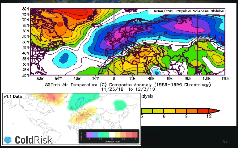 Figure 1 : The North Atlantic signal showed a strong ridge of high pressure in Greenland developing in early November.
Just after mid-November, TempRisk signal data indicated that the North Atlantic signal had spiked to a historically strong level, and continued to show significant values progressing through the 20-25 day lead time windows.
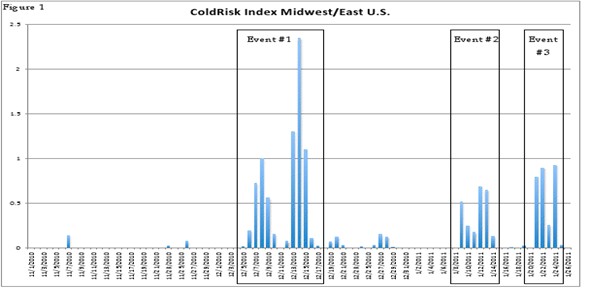 Figure 2 : The first major event of the winter of 2010-11 began on Dec. 5, peaked on Dec. 14 and ended on Dec. 29. The magnitude of the peak (2.35 CRI) was the strongest single ColdRisk day in the Midwest/East U.S. since Jan. 16, 2009.
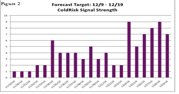 Figure 3 : The first ColdRisk signals appeared from the "initialization" on Nov. 19 and the ColdRisk signals persisted each and every initialization through Dec. 9. The signal reached significant strength on Nov. 24. In this case, a ColdRisk analysis "hit" the severe cold event with as much as a 20-day lead and an "actionable" signal emerged at a 15-day lead.
Upon entering the 15-20 day lead-time window, three newly developed signals representing key aspects of the atmosphere all crossed threshold values for statistical significance. One signal was related to a strong area of high pressure developing at the ocean’s surface in the North Atlantic alongside a string of storms in the Atlantic. This coincided with a second signal pattern that represented warm air temperatures in Greenland and bitter cold across far Northern Europe. The final signal of the three was anchored around a much faster than normal jet stream across the Southern Atlantic Ocean.
Each signal on its own is a telltale sign of the elevated chance of a cold snap two or three weeks later. However, for TempRisk users the persistence of elevated ColdRisk signals on each and every initialization from Nov. 19 to Dec. 9 was a key piece of information that this was an actionable series of signals, a full 20 days ahead of the event.
"Our ability to extend the forecast beyond two weeks is an ability meteorologists and energy analysts alike have long been waiting for," Steve Bennett, chief science and products officer at EarthRisk Technologies, said. "By delivering reliable projections of the likelihood of an extreme cold snap well in advance, energy companies can implement critical planning practices to meet heating demand more efficiently and at a lower cost."